 Skip to content


These former rail routes feature generally easy grades, lots of rich history, inviting pit stops and plenty of fall foliage.
Photo Above: The Virginia Creeper Trail connects several small towns over its 57 miles.
The Appalachian Mountains were the first formidable obstacle to America’s railroading boom—a vexing challenge for engineers. Still, by the late 1800s, the region was crisscrossed with rail lines, linking remote, mountain-cradled communities and expediting the extraction of the region’s natural resources—especially coal and timber. But, this railroading boom was relatively short-lived—and by the 1960s, many of the region’s rail lines were being abandoned.

Today, many of these Appalachian rail routes have been reimagined as rails-to-trails projects, transformed into multi-use recreational thoroughfares. Countrywide, the non-profit Rails-to-Trails Conservancy maintains more than 2,000 rail trails, located in all 50 states—and there are plenty of great options in the Blue Ridge region. Here are a just a few spectacular regional rail-trails to cycle, walk or run:
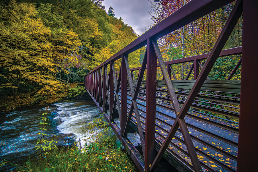
Virginia Creeper Trail, Virginia
Traversing a wild corner of southwest Virginia, the Virginia Creeper Trail stretches from the town of Abingdon to Whitetop Station, situated on the Virginia-North Carolina border in the Mount Rogers National Recreation Area.
Following the course of the historic Virginia-Carolina Railway, much of the 34-mile trail weaves through portions of the Jefferson National Forest, hugging the banks of Whitetop Laurel Creek, one of Virginia’s stocked trout streams. An ideal pit stop, the town of Damascus sits approximately at the route’s midpoint, offering a collection of trailside inns and eateries, along with more than a half dozen outfitters offering bicycle rentals, shuttle services and cycling gear.
And, between Whitetop Station and Damascus, the route is almost entirely downhill, dropping nearly 1,600 feet over the 17-mile stretch of trail. Between Damascus and Abingdon, the trail undulates gently—but still climbs enough to offer a photogenic view of the South Holston River from the South Holston trestle. At the trail’s western terminus, the town of Abingdon is anchored by a walkable historic district spanning 20 blocks full of shops and dining, while the Virginia Creeper Trail Bike Shop offers bicycle rentals and trail shuttles.
Greenbrier River Trail, West Virginia
© Greenbrier Valley West Virginia
The longest rail-trail in West Virginia, the 78-mile Greenbrier River Trail traces the path of eponymous Greenbrier River, the longest free-flowing waterway in the Mountain State.
The recreational route follows the historic path of the Chesapeake & Ohio Railroad, a freight and passenger line that once linked West Virginia with the Midwest’s booming industrial towns, arriving in the Greenbrier Valley in the early 1900s. For decades, the rail line was largely subsidized by coal and timber harvested from West Virginia. But, by the 1970s, there were few freight trains—and in 1979, the thoroughfare was handed over to the state, and repurposed as a multi-use trail open to hikers, cyclists, equestrians, and with enough snow, even cross-country skiers.
Today, the rail-trail stretches from the town of Caldwell to the Cass Railroad State Park, stringing together historic whistle-stop towns. For overnight getaways, there are more than a dozen campgrounds along the route, and both Watoga State Park and Seneca State Forest have cabins for rent. Cushier accommodations are also available along the trail in Burnsides, Caldwell, Marlinton and Seebert.
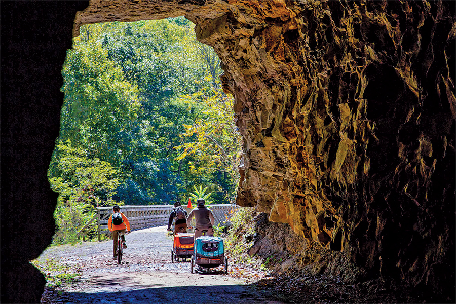
Nantahala Bikeway, North Carolina
© Explore Bryson City
A short, family-friendly ride just south of the Great Smoky Mountains National Park, the 1.2-mile Nantahala Bikeway traverses a stretch of the Nantahala Gorge, a vertiginous ravine steeped with local lore.
The word Nantahala reportedly means “land of the noonday sun” in Cherokee because portions of the cavernous canyon are so precipitous that sunlight touches them only at midday. According to Cherokee legend, the river-carved rift was also inhabited by a shapeshifting witch appropriately nicknamed Spearfinger (or U`tlun’ta), with a penchant for dining on human livers.
The bikeway also parallels a portion of the route traversed by the Great Smoky Mountains Railroad, a regional line offering scenic tours on vintage locomotives departing from a historic train depot in Bryson City.
Tallulah Falls Rail-Trail, Georgia
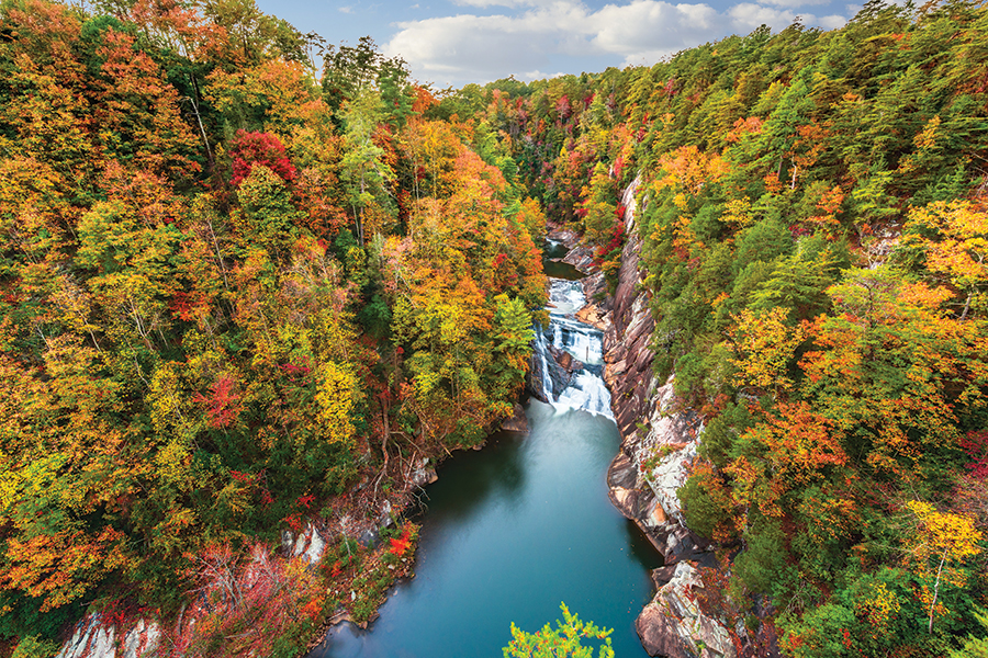
Reaching depths of nearly 1,000 feet, the Tallulah Gorge has been enticing visitors since the late 1800s. A two-mile-long chasm carved by the Tallulah River, the gorge’s centerpiece—a chain of cascades that drops more than 350 feet over the course of mile—was likened to Niagara Falls by Victorian-era travelers.
Today, the vertiginous granite gorge anchors northeastern Georgia’s Tallulah Gorge State Park, a wonderland for outdoor lovers featuring hiking and cycling trails, a swimmable lake and campsites for tents and recreational vehicles.
For a taste of the park’s natural assets, the Tallulah Falls Rail-Trail (also called the Shortline Trail) showcases a leafy stretch of the Tallulah River just north of the gorge. Beginning at Tallulah Falls Lake, the paved path parallels the waterway for 1.8 miles (or a 3-mile out-and-back trip), following the course of the Tallulah Falls Railway, a short-lived line that shuttled visitors to accommodations in the resort town of Tallulah Falls in the late 1800s.
Tweetsie Trail, Tennessee

©Tour Carter County
Bookended by Johnson City and Elizabethton, the Tweetsie Trail traverses a corner of northeastern Tennessee rich in colonial history.
Paralleling the Watuaga River for part of the way, the 10-mile, crushed stone pathway follows a railroading corridor once used by the East Tennessee & Western North Carolina Railroad, a railroad nicknamed the “Tweetsie” for its whistling steam engines. Today, the recreational route connects parks and historical sites, with more than a dozen interpretive displays posted along the trail.
For birdwatchers, Jacob’s Nature Park at Sinking Creek is wetland-dappled wildlife sanctuary, situated just a half mile from the trail’s western terminus. And there are plenty of historical sites scattered along the route too, including the Milligan Depot, a re-creation of the train station that once served the region.
The trail also rambles past the Sabine Hill Historical Site, preserving a federalist style home that once belonged to family of Brigadier General Nathanial Taylor, and Sycamore Shoals State Park, the site of a pivotal colonial outpost during the Revolutionary War—and a gathering point for the Overmountain Men credited with defeating encroaching British troops at the Battle of Kings Mountain in South Carolina.
Dawkins Line Rail Trail, Kentucky
©Dawkins KY Facebook | Tim Honaker
Now the longest rail-trail in Kentucky, the Dawkins Line Rail Trail traverses a corridor once used to haul timber and coal out of the Bluegrass State, along a locomotive route constructed by the Dawkins Lumber Company in the early 1900s.
The first section of the rail-trail was completed in 2013, and today, the 36-mile crushed stone path stretches from just outside Paintsville to the town Evanston. The route is still studded with reminders of region’s history, including century-old cemeteries and homesites, along with two dozen trestle bridges.
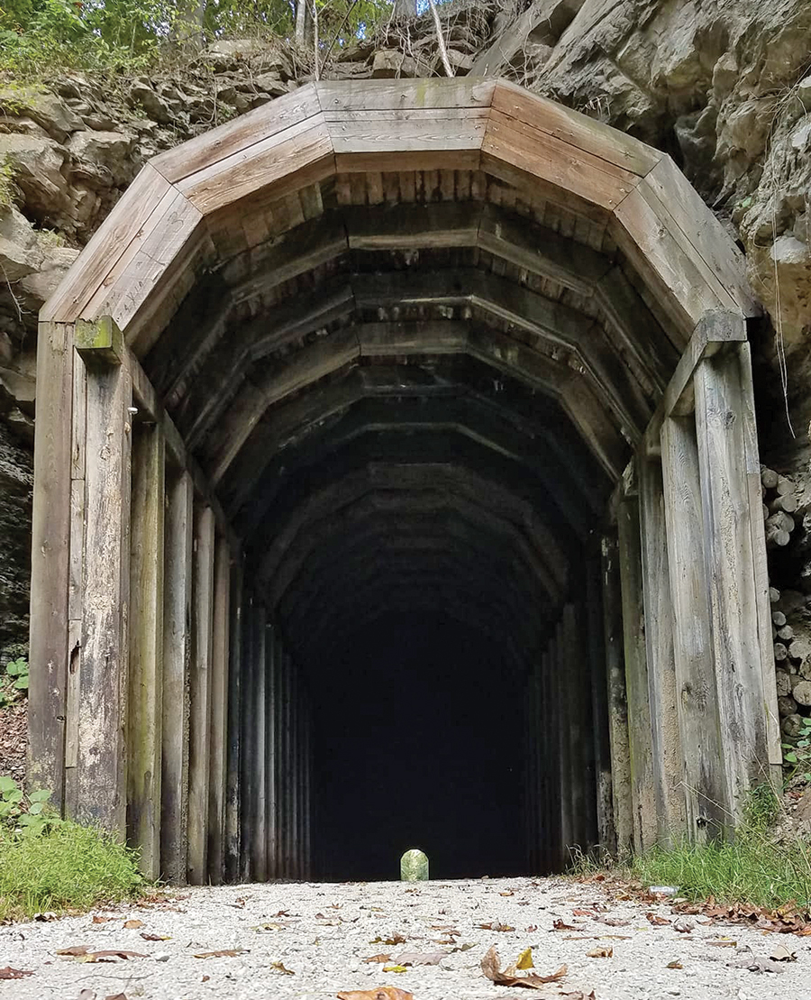
The trail’s centerpiece is the town of Royalton, a hamlet established about a century ago by the Dawkins Log and Mill Company, now recognized as one of Kentucky’s official trail towns. For day-trippers, one of the trail’s engineering wonders, the 680-foot-long Gun Creek Tunnel, sits just a few miles north of town. Beside the Swamp Branch Trailhead at the trail’s southern terminus, the Griffith Family Farm features an onsite deli and farm market loaded with artisanal snacks.
Prisma Health Swamp Rabbit Trail, South Carolina
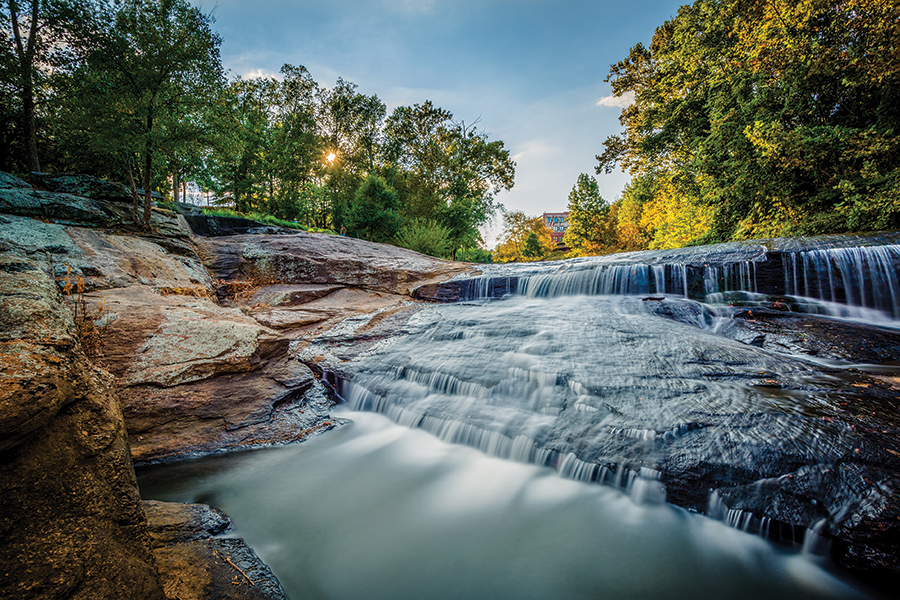
Linking the cities of Greenville and Travelers Rest in upstate South Carolina, the Prisma Health Swamp Rabbit Trail is loaded with amenities and points of interest.
Once a right-of-way utilized by the Greenville and Northern Railway, the route was transformed into a greenway after the rail line was abandoned in the early 2000s, officially opening to walkers and cyclists in 2009. Paralleling the Reedy River for 25 miles, the rail-trail meanders southward from Traveler’s Rest, traversing the grounds of South Carolina’s oldest private university, Furman University, and continuing through downtown Greenville to the campus of Greenville Technical College.
The 25-mile route is studded with trailside amenities, including shaded gazebos, restrooms and playgrounds. For a sampling of the trail’s offerings, the Swamp Rabbit Café & Grocery is situated about 5 miles from the greenway’s southern terminus in Greenville—along a route buttressed by trailside parks.
More to Explore!
© Ed Rehbein
West Virginia
Allegheny Highlands Trail
Distance: 26 miles + an additional five-mile spur | Surface: asphalt/crushed stone/gravel | Attributes: through numerous small towns; views of West Virginia’s countryside in Randolph and Tucker counties
West Fork River Trail
Distance: 14 miles | Surface: asphalt/crushed stone | Attributes: fairly flat; great for a leisurely, scenic jaunt alongside the West Fork River from Fairmont to Shinnston
Blackwater Canyon Trail
Distance: 10.7 miles | Surface: dirt/gravel | Attributes: steep grade gives a challenge through the canyon between Blackwater River and its North Fork in Tucker County; sightings of waterfalls and surrounding mountains
Virginia
Jackson River Scenic Trail
Distance: 14.4 miles | Surface: finely crushed gravel | Attributes: located in the Alleghany Highlands; flat terrain with waterfall, cliff and river views beautiful in all four seasons
New River Trail State Park
Distance: 57 miles | Surface: crushed stone | Attributes: follows the New River for 39 miles and traverses through Pulaski, Carroll, Wythe and Grayson counties; multitude of tunnels, bridges and trestles
Chessie Nature Trail
Distance: 7 miles | Surface: boardwalk/dirt/gravel | Attributes: open and forested areas from Lexington to Buena Vista with opportunities for spotting wildlife; maintained and managed by Virginia Military Institute
James River Heritage Trail
Distance: 10.1 miles | Surface: asphalt/dirt/woodchips | Attributes: braided rail network running from the Allegheny Mountains to the Chesapeake Bay; mix of wooded areas and the urban landscape of downtown Lynchburg
North Carolina
Thermal Belt Rail Trail
Distance: 13.5 miles | Surface: asphalt | Attributes: pays homage to history with rail-themed kiosks and more; runs through the charming towns of Ruth, Rutherfordton and Spindale
Elkin & Alleghany Rail Trail
Distance: 1.5 miles | Surface: crushed stone | Attributes: completed piece of a larger in-process trail to connect Elkin to Stone Mountain State Park; built on the path of the short-lived Elkin & Alleghany Railroad
South Carolina
Mary Black Foundation Trail
Distance: 1.9 miles | Surface: asphalt | Attributes: connects neighborhoods to downtown Spartanburg along a former Norfolk Southern passageway; revered for its bright signs and benches
Doodle Rail Trail
Distance: 8.5 miles | Surface: asphalt | Attributes: line was nicknamed “Pickens Doodle” by locals after the backward-traveling doodlebug insects, as the freight train had to travel in reverse from Easely to Pickens; multi-use and open from dawn to dusk
Kentucky
Prestonsburg Passage
Distance: 8.6 miles | Surface: asphalt | Attributes: nicely shaded by trees and limited elevation changes; crosses six bridges from Prestonsburg to David, one that’s framed by the top and sides of a school bus
Tennessee
Guild-Hardy Trail
Distance: 5 miles | Surface: gravel | Attributes: flat and beginner-friendly; glimpses of the Tennessee River and downtown Chattanooga through the trees
Wolftever Creek Greenway
Distance: 2.9 miles + over one mile of additional off-rail greenway | Surface: concrete | Attributes: places to explore along the way, like Imagination Station Playground and Veterans Memorial Park in Hamilton County; shaded and family-friendly
Learn more about these rail trails and others at traillink.com, created by the Rails-to-Trails Conservancy. —Sarah Riddell
The story above first appeared in our September / October 2023 issue.


")


