

The story below is an excerpt from our November/December 2016 issue. For the rest of this story and more like it subscribe today, log in to read our digital edition or download our FREE iOS app. Thank you!
The roar of outboard motors bouncing off the surrounding mountains was evidence that recent heavy rains changing Dewey Lake from its usual greenish-blue to chocolate milk’s light brown had not deterred scores of boaters. Yet, several hundred feet above them, I was all alone on the trails of Jenny Wiley State Park.
Although the 1,100-acre lake is a primary draw, the rest of the park’s 2,871 acres contains more than 10 miles of trail. The nine-mile route I’ve chosen begins with a cardiovascular workout on the Jenny Wiley Trail, followed by another 4.5 miles over terrain of moderate difficulty. (One of your shuttled cars will be parked in the middle of the hike if you choose to do this outing on two separate occasions.)

The Jenny Wiley Trail was created by volunteers in the 1970s to trace the route a pioneer woman took to escape her Native American captors in the 1700s. At one time, this National Recreation Trail stretched for nearly 200 miles across public and private lands in eastern Kentucky. There is a wide range of opinion as to what led to its demise. Some say it was the lack of sustained volunteer efforts, others blame apprehensive property owners, while a third opinion points the finger at state government. Whatever the reason, this 4.5-mile stretch is basically all that remains.
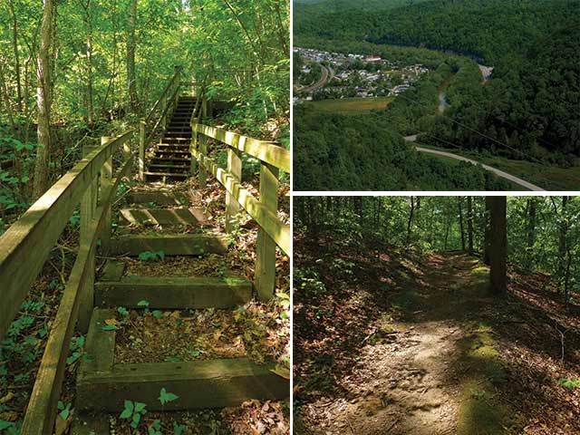
And what a rugged trail it is. The steeply-constructed stairway ascending from the trailhead establishes the grade found throughout. In addition, the narrowness of the pathway, not much wider than the width of a shoe, makes it clear that this is not a heavily-used track. Roots, rocks, and an eroded treadway had me keeping eyes groundward, even when the trail wound beside interesting sandstone rock formations on the ridgeline. I later found a YouTube video in which a state employee remarked that the Jenny Wiley Trail was the most strenuous in the entire park system. Yet, it’s evidently maintained on a regular basis; I didn’t encounter any blowdowns or overgrowing vegetation.
There are, of course, always rewards for such efforts, such as a wide sweeping view from a under a powerline of the small town of Auxier sitting beside gracefully curving Levisa Fork and a side trail leading to an open view of the lake, bordered by the Appalachian Mountains’ westernmost ridgelines. Spring flowers, including mayapple and fire pink, added their interesting shapes to the forest floor.
Despite its name, Mayapple’s fruit, which looks more like a yellowish-green egg than an apple, usually doesn’t develop until sometime in June. Fire pink’s name doesn’t refer to the color of the flower, but rather to the notch at the end of each petal (think about how pinking shears make a serrated edge on sewing material).
The steeply descending main route went through a cemetery with graves from this and previous centuries. The automobile and bicycle traffic, along with gangs of running, yelling children, were a contrast to my solitary woods walk, but a cold drink from the campground’s store was ample compensation as the day’s temperatures began to increase.
Twice more the trail rose quickly, traversed a ridgeline with additional views of the lake through vegetation and dropped just as steeply before coming to the lake where a paved road was followed into the marina. Passing by my shuttled car, I rose on a connector trail going by May Lodge and continued onto the gradually ascending Moss Ridge Trail. Bluets, rattlesnake weed and penstemon brought me by more weathered sandstone structures and onto a gently undulating ridgeline. Here the hike took a right onto the Steve Brackett Memorial Trail.
Freed from having to pay attention to the steep inclines and rugged treadway of the Jenny Wiley Trail, my mind was free to wander. And what did it wander to? Did I solve any of the world’s pressing problems or think about ways to improve my life? Nope. Freed from care, my mind decided to sing a procession of inane songs. Songs with verses such as: Rudolph the red-nosed reindeer had a very shiny nose and I’m all about that bass, ‘bout that bass, no treble, I’m all about that bass, ‘bout that bass.
The songs receded to the background once I crossed a road that could have been followed to the lodge if I had wished to shorten the hike. A variety of warblers, including bay-breasted, Nashville, worm-eating, Kentucky, Cerulean and American redstart, have been seen by ornithologists who come to walk this road during spring migrations.
Beyond is the aptly-named Lake Shore Trail with its gently meandering ups and downs a few yards above the water. I’ve never felt the need to go zipping pell mell across the surface of a lake, but I must admit that the people flying by in speeding boats looked like they were having fun. Same for the numerous anglers slowly trolling the shoreline in their rectangular jon boats, and a family of five was all smiles when they went kayaking by just as I returned to my car.
Driving away, I turned on the radio—only to hear I’m all about that bass, ‘bout that bass…


