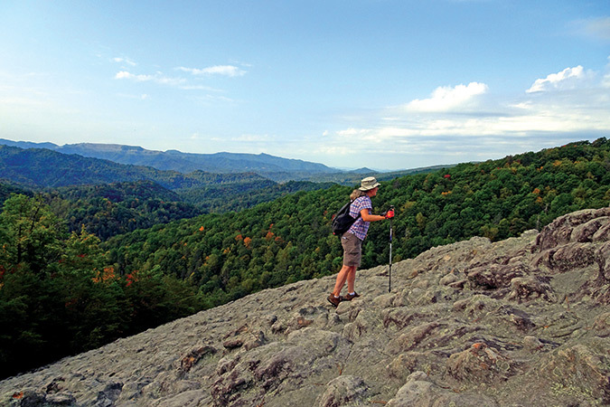
The 45-degree ascent of Knobby Rock is made over a bed of knotty rocks. Leonard M. and Laurie Adkins
Blanton Forest State Nature Preserve is home to healthy 100-foot hemlocks and other natural wonders.

Grover and Oxie Blanton bought land on Pine Mountain in southeastern Kentucky in 1928, passing it on to their descendants with the understanding that it should never be logged. Today, that land is the 3,509-acre Blanton Forest State Nature Preserve, containing the state’s largest remaining old-growth forest, with some trees having been found to be more than 350 years old.
Although more than 2,000 acres are considered to be old growth, the preserve’s trail system doesn’t necessarily go by the biggest or oldest trees. Yet, it was enough to know that somewhere in close proximity to the pathways Laurie and I were walking grow trees that were already decades old when George Washington was born in 1732.
Please note: This outing is definitely more strenuous than the majority of walks presented in this space. A little more than 900 feet of elevation will be gained in less than two miles on sometimes narrow and rocky pathways on the steep side of Pine Mountain. Expect to encounter loose footing.
Rising steadily, we came to the aptly-named Knobby Rock—although someone we met at the trailhead told us locals had historically called it “Knotty Rock.” No matter the name, the contorted slab of sandstone tilts at a 45-degree angle, providing unobstructed views of some of Kentucky’s highest mountains. One website I had consulted compared the knobs to “a pile of elephants’ knees,” but I was reminded of a bed of tree burls coated in concrete.
The Maze brought to mind a mini version of the Appalachian Trail’s Mahoosuc Notch in Maine, only the giant boulders that we had to climb over, crawl around or go under were not in a notch between two mountains, but rather on a sloping hillside.
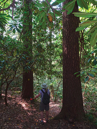
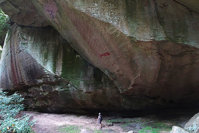
Near the apex of the outing is Sand Cave, a huge stone shelter whose rock wall dwarfs those who stand underneath. Also towering above us as we descended the mountain were possibly the tallest hemlock trees I’ve ever walked beside. Surely, this was a part of the old growth forest we had come to see, with tops of the trees reaching more than 100 feet high and bases of trunks being close to three feet in diameter.
As the walk came to an end, I thought, “Here is a place that, despite being surrounded by the modern world, still operates the way nature had planned it eons ago. Trees live for centuries, red efts turn into newts, laurel and rhododendron twist into lush thickets and sphagnum moss grows in mountain bogs.”
Thank you, Grover and Oxie Blanton, for having the wisdom—and the will—to have preserved it.
Sleep in a Classroom and Dine in the Principal’s Office
The two-story Benham Schoolhouse was built in 1926 and has been refurbished as an inn (benhaminn.com). Laurie and I thought it was a shame that the blackboards had been removed, but many of the rooms still have hardwood floors and students’ lockers still line the hallways with original terrazzo floors. The restaurant’s kitchen is appropriately situated in the former home economics classroom and customers dine in what were administrators’ offices or the teachers’ lounge.
When You Go
The Walk: A strenuous 4.5-mile outing in Blanton Forest State Nature Preserve populated by giant trees, giant rock formations, and a soaring vista of some of Kentucky’s highest mountains.
Getting there: Take U.S. 119 North from Pineville, drive 23.5 miles, turn left onto KY 840 and in approximately 1 mile turn right onto Camp Blanton Road to the parking area.
More information: A short site description and trail map is at knlt.org/blanton
Find out more about Leonard’s walking and hiking adventures at habitualhiker.com.
The story above appears in our January/February 2021 issue.