Hikes, February 17-March 6, 2010. Up, down and around all three islands of New Zealand, in mostly short hikes. About 40 miles total: Part 2: April 24-27. Over our nearly three glorious weeks in New Zealand (a gift to me – AND The Greatest Day Hiker Of Them All – from Leisure publisher Richard Wells as a 25-years’ service pin!), we walked every day – through cities, along beaches and exploring small towns, probably covering 75 miles or more over the 18 days. The brief descriptions to follow are only of the more defined hikes – through the bush, up volcanoes, onto a glacier and to some of the most amazing vistas in the whole wide world.
February 24. Guided hike in the bush of Abel Tasman National Park, along the coastline. About 5 miles.

Guide Darrell was the quintessential Kiwi neo-hippie – walking barefoot, sticking a flower in his wooden hiking pole – and also the quintessential Kiwi Plant Guy too, identifying and explaining most the trees and flowers along our leisurely walk. He also had several good lines, prime among which was spoken when two of the six people in our group expressed concerns over crossing a swinging bridge. “This one’s good,” Darrell said, “though there was one that fell down with 30 people on it in another part of the park. But this one’s good; that one was built with nails on Friday.”
We’d begun the day with Darrell with a kayak paddle out to an island in the Tasman Sea to see sea lions on the rocks surrounding it. On the way back in to Medlands Beach, where the walk began, we also got a brief glimpse of a blue penguin swimming by. The walk itself was leisurely and oft-interrupted with explanations; and also by many passing and crossing hikers, as the Abel Tasman Track is among the most popular in New Zealand. One more good bit of esoteric backcountry information from Darrell came in the form of a detailed verbal appreciation on his part for a few hundred yards after we’d crossed a particularly fine specimen, which Darrell identified by its Latin name: Wonderous pusherupperous, or something like that.
February 25. Truman Track and short walk to blowholes, Pancake Rocks and other formations near Punakaiki. About 2 miles total.
The Truman Track takes you through thick rainforest for a short distance before emerging through a “meadow” of New Zealand flax and then down onto the beach (when the tide is out, as it was for us). We waited out a shower under overhanging formations, part of the carving of the edge-of-mountains shoreline by the sea. The other walk – to another clash of mountain and sea – is also short, but offers not only the limestone formation of rocks looking like giant stacks of pancakes, but also several spots where the sea, as the tide comes in, sends waves crashing against, under and through rock formations.
February 26. Franz Joseph Glacier guided hike. About 4 miles.
From the little town of Franz Joseph, the bus takes you about a mile to a parking lot along the river that flows – whitish and fast – out of the glacier. At this point – on the little trail to get to the wide, bouldery riverbed with the water flowing on only one narrow strip – the glacier is hard to understand visually, hard to judge as to size and nature. And even as we walked across the rocks toward it, it was slow to reveal itself in terms of what was to come.
At some point our two guides stopped the 25 or so people and suggested we break into a slow group and a faster group. Very quickly, all of the 30-and-under-somethings clustered on one side and those who appeared to be on the north side of 50 on the other. The lone exception was of course The Greatest Day Hiker Of Them All, who motioned me to come along to the fast group. “I’m not going with a bunch of geezers,” she muttered to me under her breath.
But alas, when it was announced that the fast group was a little too big, she looked around and surrendered; “Yeah, I guess it’s only right for us to go over here.”
Up close but still not on it, the glacier remains hard to figure, except that you can see rocks and debris on it – explained later as having been shot out from under by water.
Before the beginning of the climb – a steep, slick section where you use a pull-rope – we get lessons in crampon; how to attach them to your boots and how to keep your feet straight ahead instead of angled as you sort of naturally want to do.
Once up on the ice, you begin to understand the magnitude of the glacier. It extends upward into the clouds, with occasional glimpses of blue beyond. As we pick our way slowly upward, people pause to put on long sleeves and then, a little higher up, windbreakers. Even young, cheeky guide Ben finally dons a jacket, shortly before he leads us through a steep, narrow crevice where we are “only the second group to go through,” and where we again need a rope and also get our shoulders wet as we rub against the blue blue ice. We climb further – until 6 p.m. on an excursion that began at 3 – and then start our way back down.
“Trust your crampons,” Ben repeats, as we all work to overcome the temptation to side-saddle it on the steep slick ice. “Keep you toes pointing down the ice and the spikes will hold.”
They do.
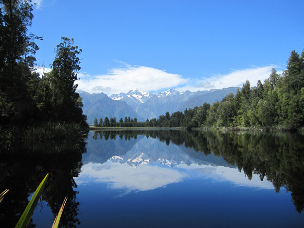
February 27. Lake Matheson loop walk. About 2 miles.
This easy, flat, warm, gentle walk was the antithesis of the one the day before, though its highlight holds a hint of the cold of the day before: Near the mid-point of the walk is a stunning view – out over the clear blue lake with Mt. Cook (New Zealand’s highest) and Mt. Tasman standing tall and snowy against the sky and also reflecting themselves ideally in the lake. The photos we took here are perhaps the “most postcard” of all we took, to the point that we placed one as the screensaver on the home computer. And not too many days after one 20-something son commented that he’d bet you could flip the photo and no one would notice, a two-something grandson sat at the computer with his little sippy cup in one hand and somehow, for the second time in his short life, FLIPPED the screen 180 degrees. And no, you can’t tell the image is upside down, though the icons are harder to read and the mouse is impossible to use.