Stunning Tallulah Gorge

L'Eau d'Or and Tempesta falls offer this stunning view from the north rim of the gorge.
The story below is an excerpt from our May/June 2018 issue. For the rest of this story and more like it subscribe today, log in to read our digital edition or download our FREE iOS app. Thank you!

The three options to explore north Georgia’s 1,200-foot-deep Tallulah Gorge offer every walker a chance to experience the drama of the falls.


When You Go

The Hike: A moderately strenuous 2-mile circuit hike above and into Tallulah Gorge, via metal staircases with close to 1,000 steps. 

Getting There: Follow U.S. 23 southward from Clayton for almost 11 miles, turn left onto Jane Hurt Yarn Road, and continue into the state park.

More Information: A handout map with trail descriptions is available from the park’s interpretive center or on gastateparks.org/TallulahGorge


One of my earliest childhood memories is gazing into West Virginia’s New River Gorge for the first time and someone explaining to me that it was the power of flowing water that had created such an incredible, and beautiful, chasm in the earth. I was truly in awe.

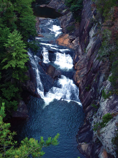
Decades later that sense of awe returned when Laurie and I stood on the porch of the Tallulah Point Overlook gift shop and we grasped that we would be walking into Georgia’s 1,200-foot-deep Tallulah Gorge. 

Tallulah Gorge State Park provides two ways to descend into the canyon. The most strenuous option, which requires obtaining a permit, follows an untrailed route across the gorge floor, going over boulders and roots before fording the river and ascending the steep gorge wall to the opposite rim. We chose the moderately strenuous option where we negotiated more than 1,000 metal steps to explore the gorge’s inner reaches.

Overlooks 2 and 3 provided soaring (and near vertigo-inducing) views of the L’Eau d’Or and Tempesta falls crashing and roaring hundreds of feet below. As stunning as nature’s scenery was, we couldn’t help but be amazed by the human engineering feat of the metal staircase that enabled us to safely descend the vertical gorge wall. Just as amazing was the “swinging” bridge suspended 80 feet above the river, allowing us to, once again, marvel at the power of this waterway. (By the way, for those intimidated by such bridges, know that this one is anchored by numerous sturdy cables that permit it to barely sway.)


… The story above is an excerpt from our May/June 2018 issue. For the rest of this story and more like it subscribe today, log in to read our digital edition or download our FREE iOS app. Thank you!

You Might Also Like:

Several bridges help hikers make their way over the stream.

Kentucky’s Bad Branch Falls: A (Fairly) Tame Trek Through the Forest

You’ll know the impressive 60-foot cascade is near when the path turns rugged.
Confederate cannons had a clear shot at the city and river.

Chattanooga’s Lookout Mountain: Spectacular Views and Civil War Echoes

A moderate 3.5-mile walk on Lookout Mountain delivers a healthy dose of delightful scenery and American history.
The boardwalk arches gently over a wetlands area.

Blairsville’s Meeks Park: Wandering a Well-Tended Gem

This bustling North Georgia green space offers nearly 5 miles of well-kept trails, waterfront views and abundant amenities for both recreation and relaxation.
Trails pass through a dense forest and a power line provides a viewpoint.

South Charleston, WV: Rediscovering a Childhood Park

In South Charleston, West Virginia, our intrepid walker returns to an area where he lived for 30 years for a pleasant stroll and an unexpected soapbox derby event.
873a4e6c-42c7-11f0-9375-1248ae80e59d-8

Seneca Adventure Trail

Originally built for a high-school cross country team, the woodsy walk offers an even treadway and delightful doses of nature.
The Cut-Through is a defining feature of Pikeville.

Pikeville, Kentucky: The Real McCoy is Just That

Pikeville, Kentucky, has put itself on the trail-map map with a varied, demanding and rewarding trail.
Downtown Roanoke, VA

Roanoke, Virginia: Mill Mountain and Downtown

The bounty of trails on Roanoke’s own mountain combine with the Roanoke River Greenway and downtown to create a fine walk.
The greenway is nearly level throughout its 8 miles.

Granite City Greenway

Mount Airy, North Carolina’s 8-mile riverside trail is a delight in many contexts, including fishing and jumping in.
The observatory functions after rain and fog lift.

Hanging Rock Raptor Observatory

The veteran and inveterate hiking couple learns anew not to let a bit of rain get in the way of the walk.
The Cool Springs Overlook looks onto the Holly Creek Valley.

Walking Fort Mountain State Park

The expertise and work of the Civilian Conservation Corps is abundantly evident in walking this 4,058-acre park.

CALENDAR OF EVENTS