


The story below is an excerpt from our September/October 2016 issue. For the rest of this story and more like it subscribe today, log in to read our digital edition or download our FREE iOS app. Thank you!
A geography and history lesson is in order before embarking on this hike.
The Blue Ridge Mountains begin in northern Georgia, but immediately split into two. The eastern arm swings toward the flatter lands of Georgia, North Carolina and Virginia to form the western boundary of the piedmont. The western arm, generally at a higher elevation, is crossed by numerous rivers which cut it into different segments, such as the Cohutta, Ellijay, Unicoi, Great Smoky, Unaka and Iron mountains. Forming an oval, the two arms come back together near the Roanoke River in Virginia.

Soon after Benton MacKaye proposed the Appalachian Trail (AT) in 1921, he and many trail supporters envisioned the pathway being routed along the Blue Ridge’s western arm. However, those who would eventually do the actual construction of the trail in Georgia convinced the others that, due to accessibility and the chance to use already existing pathways, the trail could be more readily built along the eastern arm.
Wanting to honor what might have become the original route of the AT, volunteers completed the Benton MacKaye Trail (BMT) in 2005. It begins on the same mountain in northern Georgia, but soon splits off to follow the Blue Ridge’s western arm for almost 300 miles to its junction with the AT in the Great Smokies. This hike, which makes use of both trails, provides a good introduction to the pathways, as well as some superb viewpoints, streamside walking, and the opportunity to enjoy one of Georgia’s most visited waterfalls.
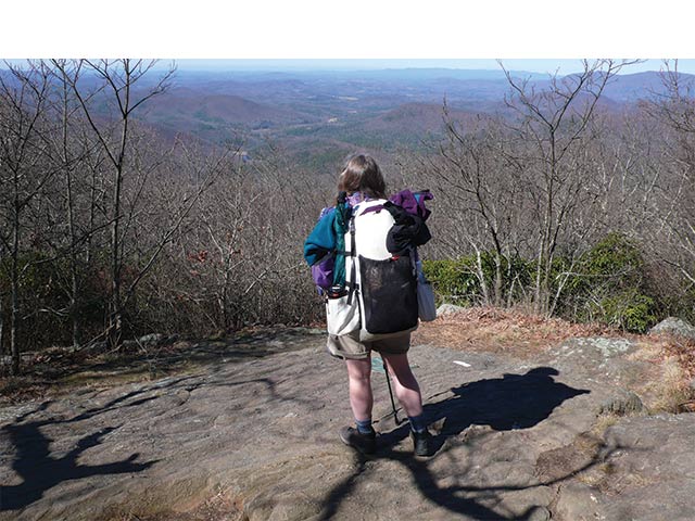
Begin the outing by crossing the road from the parking area and following the AT southward as it rises at a steady rate, bypassing two side trails to the left to arrive, in one mile, at Springer Mountain, the southern terminus of the AT. This is where the Blue Ridge divides and gazing from the summit you can see its western arm receding into the distance. To the north is Rich Mountain, crossed later in the hike.
Retrace your steps for .2 mile, pass by the trail to the Springer Mountain Shelter and bear right onto the white diamond-blazed BMT. Rising along the ridgeline that makes up the Tennessee Water Divide, the pathway soon comes to a short side trail near Ball Mountain’s summit with a view of the north Georgia Mountains. Beyond the crossing of FSR 42 at 2.9 miles, the trail makes a left to rise along the ridge, cross several creeks and pass through rhododendron thickets.
Stop to take a look at the massive tangle of rhododendron on both sides of the trail and imagine what it would be like to hike through here if the way had not been cleared for you. This is why earlier explorers called such places laurel and/or rhododendron hells.
Horace Kephart, in his 1906 book “Camping and Woodcraft,” provides a vivid picture: “A canebrake is bad enough, but it is not so bad as those great tracts of rhododendron which … cover mile after mile of steep mountainside where few men have ever been. The natives call such wastes ‘slicks’…and ‘hells’…and it is quite impossible to make a way through it without cutting, foot by foot; and the wood is very tough.”
… The story above is an excerpt from our September/October 2016 issue. For the rest of this story and more like it subscribe today, log in to read our digital edition or download our FREE iOS app. Thank you!


