The Hike: Little Sluice/Cedar Creek Loop

The view from White Rock Cliff is well worth the steep climb to it.

The story below is an excerpt from our July/August 2014 issue. For the rest of this story and more like it subscribe today, view our digital edition or download our FREE iOS app!

This 13-mile, two-state circuit offers great vistas, some steep climbs and nice campsites for a weekend outing.

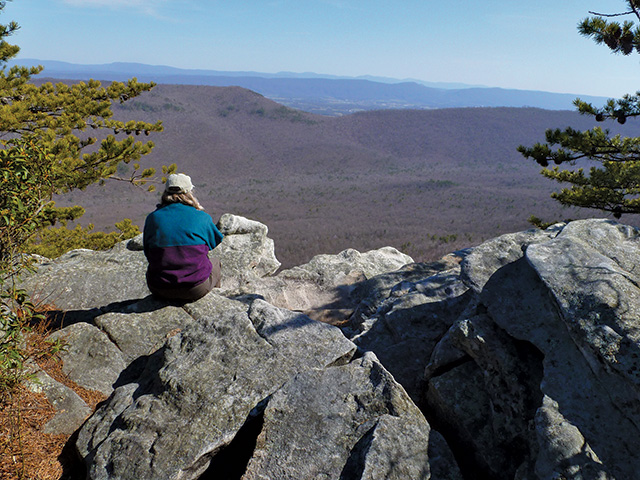
High on a ridge along the Virginia/West Virginia border is a view so expansive that it’s worth every bit of driving and hiking that it takes to reach it. I had not encountered anyone on two previous outings of this circuit hike (both on good-weather weekends) in the Little Sluice Mountain part of George Washington National Forest. So, when Laurie said she wanted to go for a quiet overnight outing away from crowds, I immediately suggested the area.

At one time, dirt logging, mining and carriage roads carried a variety of vehicles and people up these creek valleys, along ridgelines and over mountain gaps. Those days are gone, but this hike makes use of some of those roads, many now little more than footpaths, to explore environs that are miles away from paved roads. In addition to the seclusion, highlights include possible abundant wildlife, a strong-flowing high-elevation spring and the grandstand view. This walk of nearly 13 miles over moderately-rugged terrain, is best done when the daylight hours are many, or as a two-day overnighter.

The forest service has created an official parking area and put a gate across Forest Service Road (FSR) 88 since the last time I did this hike, the first of a number of changes we were to find on the outing. Walking around the gate and gradually ascending, I kept looking for what I had remembered to be the very indistinct Bread Road Trail (named in the early 1800s when wagons used it to haul food to charcoal makers cutting timer and producing fuel for nearby furnaces), but it never appeared. Instead, we encountered another change – a newer and distinct road at .5 mile into the hike. The old route had ascended at more than a 30 percent grade in places, so it was nice to follow this gradually rising road to arrive on the ridgeline at 1.6 miles, but I was sorry a bit of local history had been wiped out.


The story above is an excerpt from our July/August 2014 issue. For the rest of this story and more like it subscribe today, view our digital edition or download our FREE iOS app!

You Might Also Like:

Several bridges help hikers make their way over the stream.

Kentucky’s Bad Branch Falls: A (Fairly) Tame Trek Through the Forest

You’ll know the impressive 60-foot cascade is near when the path turns rugged.
Confederate cannons had a clear shot at the city and river.

Chattanooga’s Lookout Mountain: Spectacular Views and Civil War Echoes

A moderate 3.5-mile walk on Lookout Mountain delivers a healthy dose of delightful scenery and American history.
The boardwalk arches gently over a wetlands area.

Blairsville’s Meeks Park: Wandering a Well-Tended Gem

This bustling North Georgia green space offers nearly 5 miles of well-kept trails, waterfront views and abundant amenities for both recreation and relaxation.
Trails pass through a dense forest and a power line provides a viewpoint.

South Charleston, WV: Rediscovering a Childhood Park

In South Charleston, West Virginia, our intrepid walker returns to an area where he lived for 30 years for a pleasant stroll and an unexpected soapbox derby event.
873a4e6c-42c7-11f0-9375-1248ae80e59d-8

Seneca Adventure Trail

Originally built for a high-school cross country team, the woodsy walk offers an even treadway and delightful doses of nature.
The Cut-Through is a defining feature of Pikeville.

Pikeville, Kentucky: The Real McCoy is Just That

Pikeville, Kentucky, has put itself on the trail-map map with a varied, demanding and rewarding trail.
Downtown Roanoke, VA

Roanoke, Virginia: Mill Mountain and Downtown

The bounty of trails on Roanoke’s own mountain combine with the Roanoke River Greenway and downtown to create a fine walk.
The greenway is nearly level throughout its 8 miles.

Granite City Greenway

Mount Airy, North Carolina’s 8-mile riverside trail is a delight in many contexts, including fishing and jumping in.
The observatory functions after rain and fog lift.

Hanging Rock Raptor Observatory

The veteran and inveterate hiking couple learns anew not to let a bit of rain get in the way of the walk.
The Cool Springs Overlook looks onto the Holly Creek Valley.

Walking Fort Mountain State Park

The expertise and work of the Civilian Conservation Corps is abundantly evident in walking this 4,058-acre park.

CALENDAR OF EVENTS