Skip to content


…98…99…100…stop…lean against a tree…gasp for air.
Ascending the Approach Trail from Amicalola Falls State Park to Springer Mountain, Ga. is one of the most vivid memories of my first Appalachian Trail hike. Even though I had lost weight, worked out on the Stairmaster for at least an hour a day, and otherwise tried to get into shape, I was barely able to hike 100 steps before lungs and legs began to give out. Of course, the 58-pound pack on my back didn’t help the situation any. All of this combined to make me wonder what I had gotten myself into.

I’m not the only one to have experienced this. The route is famous (or maybe infamous) for being a rude awakening to those planning on hiking from Georgia to Maine. Every year, there are stories of people turning around somewhere along its 8.8-mile length and abandoning the dream of becoming a 2,000-miler. In his best-selling “A Walk in the Woods,” Bill Bryson wrote: “The hardest part was coming to terms with the constant dispiriting discovery that there is always more hill…The elusive summit continually retreats by whatever distance you press forward…as unattainable as before.”
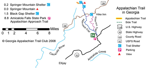
There has been only one major Appalachian Trail relocation in Georgia, that of moving the southern terminus to Springer Mountain in 1958, when development around the original terminus, Mount Oglethorpe, became incompatible with the trail’s wilderness character. With the summit of Springer inaccessible to automobiles, many hikers begin their AT trip by taking the Approach Trail from Amicalola Falls State Park. Unbeknownst to many of them, they are walking upon the original route that wound its way through the Amicalola Range from Oglethorpe to Springer. They are also following in the footsteps of some of the pathway’s most renown pioneers, including Earl Shaffer (first thru-hiker), Gene Espy (second thru-hiker), and Chester Dziengielewski (first southbound thru-hiker).
Thanks to the construction of the Len Foote Hike Inn just before the turn of the 21st century, you can make the Approach Trail ascent a bit easier by carrying just a day pack, as the inn provides a soft bed, all linens, a shower, and dinner and breakfast.
Of course, you’re still going to have to climb a little more than 2,000 feet of elevation over some rugged terrain, and 600 of those feet are going to be gained within the first mile, which rises steadily on a 604-step staircase to the falls. (You could leave your car at the parking lot near the falls and not traverse this first mile, but where’s the fun in that? Remember, this is a hiking column, one that encourages you to hike as many miles as possible.)
The state of Georgia established the state park in 1948 to protect one of its most impressive waterfalls. In a series of cascades, Amicalola Falls descends nearly 500 feet down the face of Amicalola Mountain in only three-tenths of a mile.
Beyond the falls – and the side trail to the Len Foote Hike-Inn – the Approach Trail enters Chattahoochee National Forest and it is at about this point that an odd phenomenon occurs: It’s been said you could outfit yourself pretty thoroughly with the items prospective thru-hikers have abandoned in an effort to lighten their loads. I have seen everything from rain jackets to cast-iron skillets to books to expensive tents left beside the trail. One year Laurie and I found two five-pound canned hams; later that evening we camped with two 17-year old brothers who confessed they were theirs and said they still had another can each.
The other end of the Hike-Inn Trail is at about the five-mile point but, for now, you’re going to continue on the Approach Trail to arrive at Springer Mountain 8.8 miles into the journey. You’ve worked hard to reach this point, so take it all in. This is where the Blue Ridge Mountains divide, and gazing from the summit you can see the western arm going over Rich Mountain and receding into the distance to the Cohutta Mountains. Unseen to you, the other arm swings eastward, forming the western boundary of the piedmont in Georgia, North Carolina, and Virginia. Forming a large oval, the two arms come back together near Roanoke, Va. If you don’t happen to meet an eager thru-hiker wannabe here, take a look at the trail register cached nearby to read their thoughts upon beginning such an epic undertaking.
Retrace steps back to the Hike-Inn Trail and follow it for almost a mile to the inn for an evening’s worth of relaxation. Tomorrow it’s an easy day as the route is one that tends downward as you follow the other portion of the Hike-Inn Trail to the falls and descend the Approach Trail’s steps back to your car.
The Len Foote Hike Inn
Operated by the Appalachian Education and Recreation Services (affiliated with the Georgia Appalachian Trail Club), the inn is LEED-certified, meaning it was constructed and operates in an environmentally friendly way. Twenty bunk rooms can accommodate two people each (a child could sleep on the floor); the main lodge building has the Sunrise Room, with a library, wood-burning stove, and an eastward-facing porch. The dining room is where the family-style dinners and breakfasts are served. There are no electrical outlets for guest use, but the bath house does have hot showers and blow dryers.
Although walk-ins are accepted, it is best to make reservations early, especially as the inn fills up quickly at this time of year. Reservations may be made by calling 800-581-8032, Monday through Friday from 10 a.m. to 5 p.m. For more information please go to hike-inn.com.
When You Go
The Hike: A strenuous 18.8-mile circuit hike of the Approach Trail to the Appalachian Trail’s southern terminus, Springer Mountain in Georgia, and an overnight stay at a backcountry lodge.
Getting There: Drive westward from Dahlonega on GA 52W/GA 9S. Turn to the right in 4 miles to stay on GA 52W, and continue another 14 miles to turn right into Amicalola Falls State Park. The Approach Trail begins behind the visitor center.
Trail Information: “The Appalachian Trail Guide: North Carolina/Tennessee” is available from the Appalachian Trail Conservancy (atctrailstore.org; 888-AT-STORE).