Johnson Farm at Peaks of Otter


The story below is an excerpt from our Jan./Feb. 2016 issue. For the rest of this story and more like it subscribe todayview our digital edition or download our FREE iOS app!


Combine a walk to the farm with a trek over Harkening Hill and you have a 3.9-mile walk full of history and discovery.


The Johnson Farm/Harkening Hill loop at the Peaks of Otter at Blue Ridge Parkway milepost 85.9 is one of my “go-to” hikes. I go to it when I want a bit of exercise, but don’t want to put forth the effort involved in a major mountain trek. I go to it because it’s fairly close to home and I don’t have to invest hours to reach it. I go to it when hunting season brings the cracks of rifles to the mountains, because that activity is prohibited on parkway property. But, mostly, I go to it because I just plain enjoy what I experience each time.

Unlike the famous saying, this familiarity does not breed contempt. Rather, I find that I have a sense of excitement, and even wonder, knowing that I may see something I have overlooked, get to observe an animal going about its daily life, or learn more of the history of the area.

My last outing is a case in point. I know that the Peaks of Otter area was a thriving community and tourist area, complete with the large Hotel Mons, as early as the mid-1800s, but the person at the visitor center told me of an occurrence during the Civil War I was unfamiliar with. In June 1864, Confederate soldiers, following what is now the route of Va. 43, swung around the southwestern side of Harkening Hill, downing trees as they went in order to slow the pursuing Federal forces. The latter made it past those obstacles and advanced along a primitive road that is now the parkway—and helped themselves to the hotel’s storehouse of food.

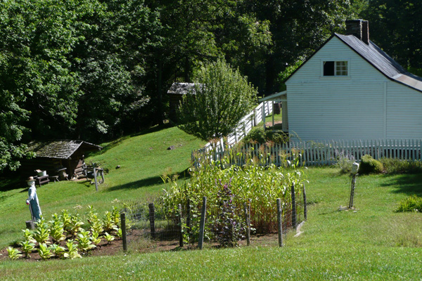
The Johnson Farm Trail begins at the visitor center and goes by two trail intersections in .25 mile. Stay to the right as the first trail comes in from the left (this is the return portion of the Johnson Farm Trail), but bear left when coming to the second intersection. (The trail to the right goes .1 mile to the Peaks of Otter Lodge.) It was in this area that I learned yellow-bellied sapsuckers leave rows of small circular holes in tree trunks in their pursuit of insect sustenance.


The story above is an excerpt from our Jan./Feb. 2016 issue. For the rest of this story and more like it subscribe todayview our digital edition or download our FREE iOS app!


You Might Also Like:

Several bridges help hikers make their way over the stream.

Kentucky’s Bad Branch Falls: A (Fairly) Tame Trek Through the Forest

You’ll know the impressive 60-foot cascade is near when the path turns rugged.
Confederate cannons had a clear shot at the city and river.

Chattanooga’s Lookout Mountain: Spectacular Views and Civil War Echoes

A moderate 3.5-mile walk on Lookout Mountain delivers a healthy dose of delightful scenery and American history.
The boardwalk arches gently over a wetlands area.

Blairsville’s Meeks Park: Wandering a Well-Tended Gem

This bustling North Georgia green space offers nearly 5 miles of well-kept trails, waterfront views and abundant amenities for both recreation and relaxation.
Trails pass through a dense forest and a power line provides a viewpoint.

South Charleston, WV: Rediscovering a Childhood Park

In South Charleston, West Virginia, our intrepid walker returns to an area where he lived for 30 years for a pleasant stroll and an unexpected soapbox derby event.
873a4e6c-42c7-11f0-9375-1248ae80e59d-8

Seneca Adventure Trail

Originally built for a high-school cross country team, the woodsy walk offers an even treadway and delightful doses of nature.
The Cut-Through is a defining feature of Pikeville.

Pikeville, Kentucky: The Real McCoy is Just That

Pikeville, Kentucky, has put itself on the trail-map map with a varied, demanding and rewarding trail.
Downtown Roanoke, VA

Roanoke, Virginia: Mill Mountain and Downtown

The bounty of trails on Roanoke’s own mountain combine with the Roanoke River Greenway and downtown to create a fine walk.
The greenway is nearly level throughout its 8 miles.

Granite City Greenway

Mount Airy, North Carolina’s 8-mile riverside trail is a delight in many contexts, including fishing and jumping in.
The observatory functions after rain and fog lift.

Hanging Rock Raptor Observatory

The veteran and inveterate hiking couple learns anew not to let a bit of rain get in the way of the walk.
The Cool Springs Overlook looks onto the Holly Creek Valley.

Walking Fort Mountain State Park

The expertise and work of the Civilian Conservation Corps is abundantly evident in walking this 4,058-acre park.

CALENDAR OF EVENTS