


Splendor At Your Feet
The warm sun plays against the morning chill; that sort of sweet-and-sour effect that occurs only on a perfect spring morning. Take your time enjoying the beautiful days and the scattered groups of spring flowers along the trails and drives of the Smokies.
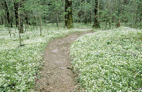
This was our first hike to Porter’s Flat – all we knew was “the wildflowers are good about a mile up the trail.” With small children in tow, we weren’t looking for a very challenging excursion, just a chance to kill off the cabin fever of a late and long winter. The kids were getting whiney, and the flowers had been only average; we were about ready to turn around to go back to the car when BAM! Like Emeril throwing around his Cajun essence – there it was.

“Good” didn’t describe it – what an understatement – carpets of white phacelia stretched as far as we could see, around the next bend, for all we could tell to the ends of the earth. We had gone through the looking glass at Porter’s Flat; Alice never had it so good.
Come with me to my favorite places in the Smokies for the spring bloom, places I return to year after year for the best flowers in the park. In general, good displays start in mid-April at the lower elevations (around 2,000 feet) and continue at various higher locations to the end of the month. The past three years have given us earlier-than-average blooms, sometimes by almost two weeks, so there is some year-to-year variability. The third and fourth weeks are fairly reliable if you have to request your time off in advance.
The 2001 Wildflower Pilgrimage will be April 26th-28th; a variety of activities and naturalist-led walks are part of this excellent yearly program. By the end of April often into early May the highest elevations like Newfound Gap will show their colors if you missed it down lower. The bloom seems to proceed upward at about 100-200 feet of altitude per day if there aren’t any major frosts to slow things down. The park backcountry desk at 865/436-1297 will probably have the most current and reliable information on what’s blooming and where. Many splendid displays can be seen from the car, and several short easy walks add to the possibilities. The hike to Porter’s Flat is the longest walk of the bunch, and the most rewarding.
Porter’s Flat
Though it’s not listed by name on all maps, finding this special place is easy. The road to the Greenbrier area of the Great Smoky Mountains National Park turns off of U.S. 321 about five miles east of Gatlinburg. At 2.7 miles you will pass a small picnic area with a pit toilet, 1/4-mile farther brings you to an intersection with a left turn crossing a bridge towards the Ramsay Cascades trailhead. Proceed straight ahead past this turnoff approximately 1/2 mile to the Porter’s Creek trailhead, which has ample parking. The easy hike follows an old roadbed a little over a mile to the Porter’s Flat area; gradually the roadbed gives way to a wide, well-maintained trail. This is an easy hike, a bit more difficult than mall walking, but not much. For the first mile the flowers will be about average and you will wonder what the hoopla is all about. After you cross the third footbridge however, you will be in wildflower heaven. The peak bloom varies a bit depending on weather, but mid-April in an average year will be quite pretty; I am always surprised at how early Porter’s Flat seems to peak for its elevation – about 2,400 feet.
Bud Ogle Place and the Roaring Fork Motor Nature Trail.
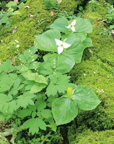
Bud Ogle Place is a great location for the beautiful crested dwarf iris, which are plentiful within a few yards of the picturesque cabin. A large handsome dogwood grows nearby. There is an easy half-mile nature trail here where you can find the relatively uncommon showy orchids and possibly a few of the rare yellow lady’s slippers. Trilliums, violets and wakerobin are common here. After a rain the ground may be littered with silverbell blossoms.
Turn at light #8 in Gatlinburg and follow the road uphill to Cherokee Orchard Road and on to Bud Ogle Place, about three miles, The Roaring Fork Motor Nature Trail lies just a mile farther, just past the parking lot for Rainbow Falls trailhead. The lights have numbers on them so you don’t have to count; light #10 is the first one you come to from Sugarlands Visitor Center in the park.
Set your odometer to “0” at Bud Ogle parking lot for this section; the motor nature trail becomes one way at mile 1.0. The nature trail is steep and narrow and not well suited to RVs or trailers; the road loops and returns to Bud Ogle if you decide against the nature trail that empties you onto U.S. 321 on the east side of town.
There are flowers all along the Roaring Fork Motor Nature Trail; you will find excellent displays of trillium grandiflora (the big white ones with the slightly floppy leaves) near Eph Bales Place at mile 4.1. You will have passed the parking lot for Grotto Falls at mile 2.1, a much easier hike than Rainbow Falls, although neither is particularly great for wildflowers. Wildflowers continue to grace the roadside until you reach the Place of a Thousand Drips at mile 5.7, a delightful and photogenic roadside cascade. Shortly after this you return to Gatlinburg.
Chimneys Picnic Area
If you are on a tight timetable, this is your place. A little less than five miles from Sugarlands Visitor Center heading up toward Newfound Gap on U.S. 441 brings you to a very large day-use area with picnic tables, several well maintained bath houses (no showers) and one of the finest wildflower displays anywhere, usually around the third week in April. The white phacelia covers the ground like snow; up close the blossoms are even reminiscent of snowflakes with intricate fringing around the edges. The sweet nectar attracts bees in abundance so be careful when you are getting a snoot full of the fine aromas.
Many other wildflowers grow here, too many to list. Here are the finest colonies of yellow trillium I have ever seen, often mixed with violets and blue phlox (which seem more purple to me). A short nature trail into the Cove Hardwood forest will give you a chance to stretch your legs, but the dense forest canopy cuts down on the display in many areas, although it’s still a very nice walk. You’ll notice that the phacelia like their sunshine, and are usually close to the road or in more open areas of forest. The excellent beds of phacelia and trillium continue up the road for another mile or so in dense patches wherever sunlight is adequate, and there are several pullouts giving easy access. If you pull off on a grassy shoulder be especially careful that your vehicle doesn’t cut up the soft turf – these scars take years to heal.
Little River Road and the Chestnut Top Trail
From Sugarlands Visitor Center go west as though to Cades Cove. The flowers become excellent as you approach the Sinks, about 11 miles in. Metcalf Bottoms picnic area (mile 9) has the last facilities until you get to Townsend or Cades Cove. The rocky outcrops along the road shelter large colonies of columbine, and in more open areas are many large colonies of purple phacelia. Unless you are accustomed to purple snow, this won’t be as visually confusing as the white at Chimneys Picnic Area. The usual suspects are all to be found here. Follow this road on to the Townsend “Wye” (“Y”) where you will find the Chestnut Top Trail. The displays along Little River Road including the Chestnut Top Trail are usually best around the third week in April as well. About two miles from the Wye you will find restaurants, gas and picnic supplies in Townsend.
For the Chestnut Top Trail, park in the large parking lot at the Wye and look across the road at the opposite hillside. Along the road itself are many gorgeous bouquets of all the flowers you have grown accustomed to. The trail cuts a switchback up this hillside and although moderate in grade, you don’t have to go too far. The best growths are probably in the first half mile or so. Though I am partial to Porter’s Flat, at least one authority considers this the best wildflower trail in the park. An added bonus is being able to get a feel for the bloom before committing to the walk. If the flowers near the trailhead are tired and tattered this area is probably past its peak. Then it’s probably time to head to the high country.


