

From Revolutionary War history to flea markets, state parks to bluegrass, a single road through South Carolina’s Upcountry is a cross section of the area’s beautiful variety.
According to its original intent, S.C. Highway 11 was planned as an alternate route for commuters driving through South Carolina, but wanting to avoid the traffic on the six-lane Interstate 85.

However, few drivers take the 130-mile scenic highway hugging the perimeter of the Blue Ridge Mountains and stretching from the South Carolina’s state line with Georgia to within a few miles of the North Carolina boundary.
They don’t know what they’re missing, especially in the late fall when the leaves turn a lush variety of yellows, reds, oranges and greens.
Highway 11 is more than just a nationally recognized scenic route, as my wife Shonda and I realized after driving the entire stretch from south to north last fall. It’s the home of eclectic groups of homes, businesses, state and national parks and roadside attractions.
Highway 11 can be accessed from Interstate 85 at exit 1, just past the Georgia border. A large fireworks stand and a couple of small gas stations, realty agents hawking land on nearby Lake Hartwell and super-developed subdivisions dot the first few miles.
The view is hardly amazing at this point, but not much past, at mile marker 4.2 we see – a giant blue question mark? – on the side of the road. My wife notices the smaller sign next to it: peach cider for sale.
The Curiosity Shop is just what the sign claims to be. The two-story cabin is jammed with knickknacks, South Carolina memorabilia, homemade jams, carved wooden soldiers – and of course peach cider by the caseful.
Joan Carter, an employee, says the big question mark pulls most customers in, but few leave without buying some of the peach cider.
Back on the road, the panoramic views are of fall foliage, hay bales, farms and wildflowers.
At marker 13.9, we have our first glimpse of the towering blue mountain wall that caps the edge of South Carolina.
Music and Biscuits
At mile marker 15, the Highway 11 Flea Market sits on the left side of the road. A collection of small stands around a large gray wooden building that serves as the main exhibition hall, the market looks as if it’s been here for decades.
In reality, it’s been just seven years.
It draws an eclectic group of visitors on the weekend full of locals, people in their Sunday best and travelers just dropping through.
Tillmon Webb strums his dobro guitar every weekend here as he waits to sell merchandise. There is almost always a crowd crouched around Webb as his fingers work the strings, knocking out bluegrass music.
“I can sit here all day and play,” says Webb, 55. He’s been playing for 42 years.
The market is open five days a week, but Saturday is the most popular day, he says. People browse through crafts and quirky collectibles. The floor is a patchwork of carpets mixed with concrete and the air smells of ham sandwiches and biscuits.
Back on the road, we pass another flea market and some small bars and pull our car into the little town of West Union at mile marker 19.4.
It’s also the first stoplight we’ve come across so far on the highway.
And it’s also the first place to find fast food restaurants, grocery stores and auto shops.
Scenic Parks
The next major landmark is the William Jennings Bryan Dorn Bridge over Lake Keowee. The view of the mountains here is absolutely gorgeous.
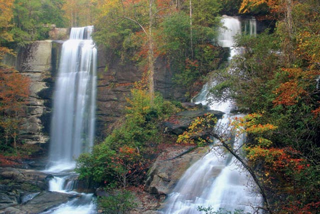
Not far after crossing the bridge, we pass into Pickens County, home to several state parks including Lake Toxaway, Table Rock and Jones Gap. It’s probably the most scenic section of the highway.
Around mile marker 50, we get our first glimpse of the 3,000-foot-plus giant cliff face that gives Table Rock State Park its name. The park’s 3,083 acres includes a swimming and fishing lake, hiking trails, canoe and kayak rentals, campsites and cabins.
From Table Rock, we drive down the road and find Aunt Sue’s Country Corner, with ice cream, live animals, pottery, plants, candles and gospel music in a series of log cabins.
Aunt Sue’s also has a great inexpensive restaurant that is also vegetarian friendly. Pictures of the late U.S Sen. Strom Thurmond and other dignitaries line the walls, mixed in with old time farm equipment.
A trip to Aunt Sue’s wouldn’t be complete without a scoop or two of Mayfield Dairy ice cream in the main lobby.
Owner Jimmy Bikas says the lure is people like the ambience, fast service and friendly clientele.
“It’s like a small, intimate Cracker Barrel,” he says.
Another popular attraction just down the road is the Pumpkintown Opry, which has a barbecue joint as well a collection of small shops.
At mile marker 59 we dart into Greenville County, with a population close to 400,000. But up here on Highway 11 is an entirely different universe from the sprawling metro area.
Apples and Dirt Tracks, Golf Courses and Horse Farms
We discover Big J Blythe Shoals Produce at mile marker 62. While it offers the prerequisite of apples, boiled peanuts and local-grown groceries, the green and yellow concrete block building has gone through several previous incarnations including restaurants and deli.
“People come to Highway 11 to see a little bit of everything,” says Joyce Bickerstaff, who works for Big J at one of the many produce stands along the road.
The next 20 or so miles are a collection of dirt race tracks, million dollar homes, horse farms, golf courses and small restaurants. Apple and peach orchards line the sides of the road.
At mile marker 90, we reach an intersection with Interstate 26, which changes the complexion of Highway 11. For the first time in about 60 miles, we realize how close we are to urbanization.
But the feeling doesn’t last long as we plunge back into acres and acres of farmland. Kudzu hangs off power lines and gnarled old trees. The white buds in the cotton field sparkle in the late afternoon sunshine.
Around mile marker 108, we pass through the Strawberry Hill Farms, which if you drive by at the right time of day is a pretty magnificent sight, as giant water hoses spray next year’s crop.
A trip on Highway 11 wouldn’t be complete without a trip to the Cowpens National Historic Site (see sidebar).
At mile marker 119, we realize we’re almost at the end of our trip when we see the Gaffney peach looming in the distance.
We get to the intersection of S.C. 11 and Interstate 85 almost six hours and 120 miles of traveling later.


