You can scale your walk just to view the stunning formations, or to get up-close and personal.
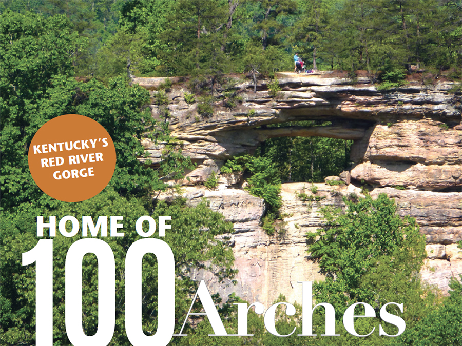
Getting to the Red River Gorge in Kentucky may involve a bit of a drive for some Blue Ridge Country readers, yet it’s worth those few hours on the highway. Memories of towering cliff faces, lush vegetation and soaring natural rock arches have lured me back time and again. With more than 100 arches, the area has the highest concentration of such formations east of the Mississippi River.
One of the most intriguing is Double Arch, reached by the out-and-back Double Arch Trail of less than five miles. That route runs below and onto the arch. However, I most often find myself doing a different outing. It’s a looping route of five miles that not only provides a better perspective on the arch from a distance, but also passes several other interesting rock formations.

Less than two miles in is the soaring viewpoint that, to me, is the big draw. The Auxier Ridge Trail breaks out of the forest and onto an open rocky area with steep cliffs on both sides. Nearby is the stone tower of Haystack Rock and across the gorge is Raven Rocks, which gained infamy as the site of two hang gliders meeting death in 1976. Deep on the gorge floor are farm fields, barns and houses—such a different view than those into West Virginia’s narrow New Ridge Gorge or Georgia’s waterfall-filled Tallulah Gorge.
When You Go:
The Walk: An easy out-and-back of less than four miles to a view of Double Arch with the option of continuing on a moderately strenuous loop going by Castle Rock. Total distance that way would be five miles.
Trailhead Directions: Take Exit 33 (about 10 miles east of Stanton, Kentucky) off Bert T. Combs Mountain Parkway, go north .1 mile on KY 11 and turn right onto KY 15. Turn left onto (gravel) Tunnel Ridge Road in 3.5 miles and continue another 3 miles to the Auxier Ridge Trail parking area on the right.
More information: Brief descriptions of the trails, along with a topographic map, are available on fs.usda.gov/Internet/FSE_DOCUMENTS/fseprd491186.
To the west is Double Arch, its thick upper span separated from the thinner lower arch by just a few feet of air. If you’re lucky, there will be people walking across it and their small size will help you gauge just how large the span really is.
If you suffer from cremnophobia—a fear of steep cliffs—or had just walked out for the view, this is the place to turn around. From this point the Auxier Ridge Trail continues ahead for the next half mile on an exposed ridge that gets progressively narrower. Definitely a place to keep an eye on wandering children or pets.
The easy walk becomes moderately strenuous as two sets of steep stairs bring the trail to the base of Courthouse Rock, described in “Hiking Kentucky” as a “boulder as big as an office building.” Just beyond is an intersection that provides the opportunity to hike over to Double Arch. My choice has always been to take the undulating Castle Rock Trail back to the Auxier Ridge Trail to return to the parking lot.
END OF PREVIEW
The story above appears in our March/April 2019 issue.