


The story below is an excerpt from our July/August 2015 issue. For the rest of this story and more like it subscribe today, view our digital edition or download our FREE iOS app!
The factors influencing how the two Virginias were created in 1861 and made official in 1863 reach back as far as the late 1700s, and came to a head over conflicts involving slavery, railroads, resources and more.
Spring, 1861: Confederates attacked Fort Sumter, new President Abraham Lincoln mobilized the Union army and Virginia joined the wave of southern states voting to secede from the United States.
Delegates to the secession convention from northwest Virginia, who had opposed the split from the U.S., quickly left Richmond and returned home. As the war hit Virginia over the next few months, Union troops experienced early success in what is today West Virginia. The gains established the reputation of Union Gen. George McClellan, who subsequently left the front when he was handed command of the Army of the Potomac. It also gave those northwest Virginia delegates the opportunity to meet in Wheeling for two conventions and begin the process of forming a new state.

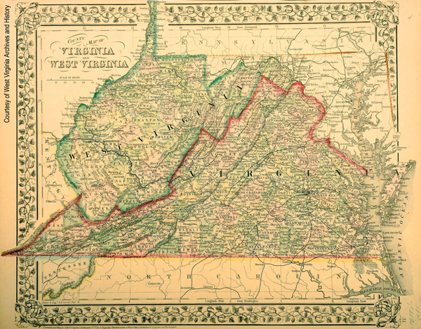
One obvious question loomed over the proceedings: Where should the delegates draw the boundary between Virginia and the new state? The answer involves railroads, slavery, troop movements during the war and, as always seems to be the case, politics.
“There was a group that wanted West Virginia to be reasonably small,” says historian Kenneth Noe of Auburn University. “They weren’t eager to go much farther than Charleston. There was another group that really wanted all of western Virginia down to North Carolina and Tennessee. Practically, it became a question of what could they actually control.”
Those decisions made by a small group of northwest Virginians in the 1860s continue to affect those who live in the mountains along the West Virginia border today.
The Split’s Varied Beginnings
The real story of the Old Dominion’s division into two states began decades before the war and falls under a number of different categories:
• Cultural and ethnic differences.
Starting in the late 1700s, a wave of Irish and German immigrants steadily streamed into northwestern Virginia, bumping against the English settlers who had ventured west from the coastal Tidewater region. Geographic and socioeconomic differences between eastern and western Virginia grew deeper over time.
• A voting system that favored Virginia’s eastern counties.
The relatively small size of Virginia’s eastern counties meant that the Tidewater region wielded a disproportionate amount of political power.
“The western discontent with Richmond begins right after the [American] revolution in some ways,” says Ken Fones-Wolf, a history professor at West Virginia University. “The dividing line really becomes the Shenandoah Valley. The Tidewater area was very heavily slave-plantation culture, and it had a disproportionate share of power. The Valley region had much less and then the mountain region had far less.”
The discontent built after the War of 1812 before finally culminating in two different constitutional conventions, in 1829-30 and again in 1850, that ultimately gave more political representation to the west while effectively capping the tax rate on slaves, pleasing eastern plantation owners.
• Railroads and public projects that linked the Shenandoah Valley and Southwest Virginia to Richmond.
In the mid-1800s, the Virginia General Assembly began to invest in significant capital improvements that changed the economies of the Shenandoah Valley and Southwest Virginia, expanding slavery and tying them more tightly to eastern Virginia.
“In the 1850s, the Valley of Virginia started voting more and more with the east,” says John Stealey, recently retired professor of history at Shepherd University. “First, Virginia was spending internal improvement money in the Valley of Virginia. It spent a lot of it, and it didn’t go any further than that. Second, the Valley of Virginia had areas with a good bit of slavery, where the west did not. That was the unifying issue as far as eastern Virginia and portions of western Virginia.”
In 1847, after several failed attempts, Virginia legislators created the Virginia & Tennessee railroad, running west from Lynchburg to Salem and then southwest to what is now Bristol. Passing the bill to create the railroad required some last-minute heroics from Del. Thomas Tate of Smyth County, who pretended to faint on the House floor to delay a key vote and buy pro-railroad legislators some extra time to find more support. Tate’s “faint” involved more than just falling down, as several doctors who were present rushed forward and began to bleed Tate, a common medical treatment at the time.
The V&T railroad brought new economic opportunities to southwest Virginia even as it linked the region to the rest of the state with an iron bond, Noe says. Farmers and business owners who took advantage of the new transportation link were able to get ahead of their neighbors, ultimately leading to a greater gap between rich and poor and the rapid growth of slavery in southwest Virginia in the 1850s.


