Rock City Barns: Disappearing Icons of the Blue Ridge

This nearly gone structure is located on old U.S. Highway 19 about a mile inside the Bryson City, North Carolina, city limits and across from the Bear Hunter Campground.

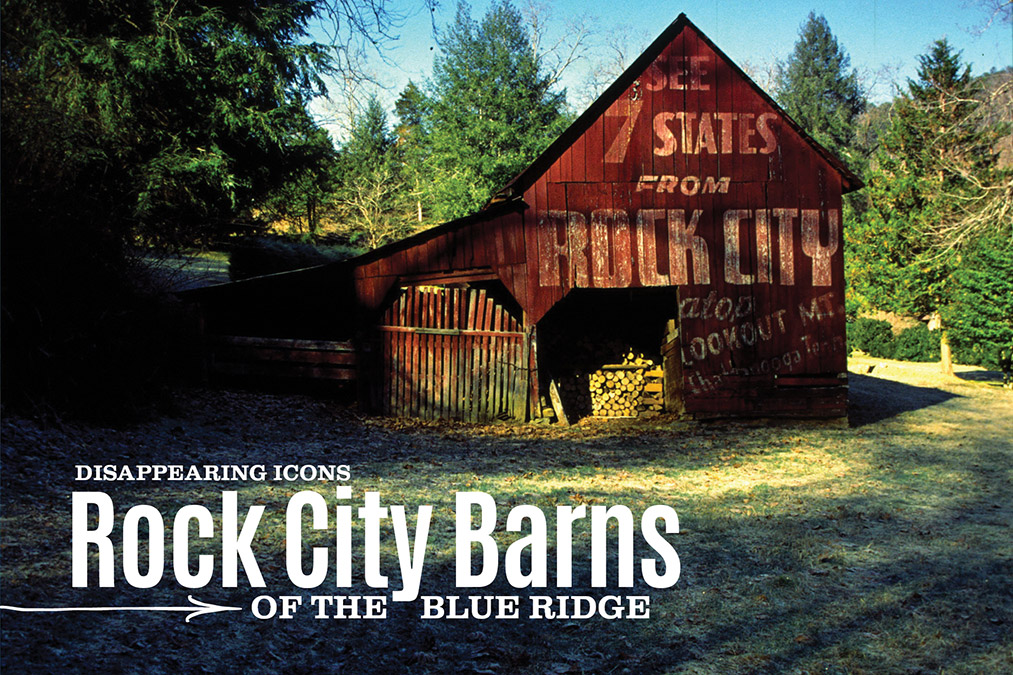
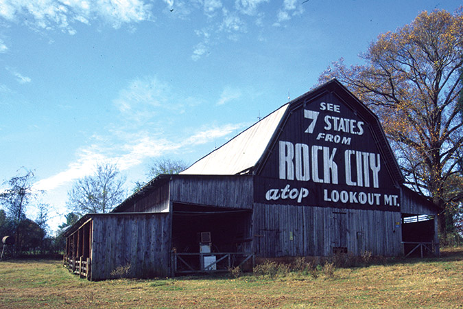
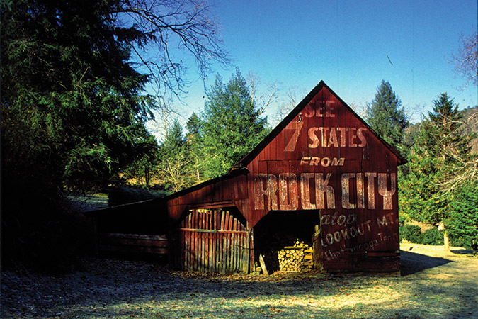
David Jenkins, who set out in 1994 to find all of the messaged barns for his book “Rock City Barns: A Passing Era,” laments here that time has greatly reduced the number of barns that once formed a perfect outdoor marketing campaign. These then-and-now shots define the decline, with the exception of few barns that are well-maintained.

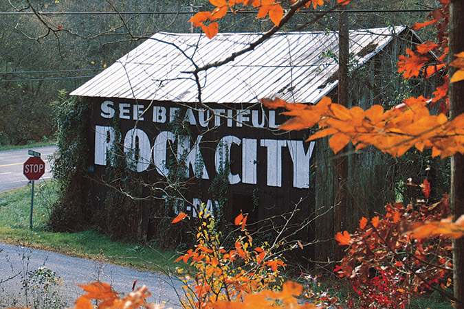
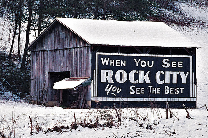
Once there were nearly 900 of them, scattered from Michigan to the Florida line, from the Carolina coast to Texas. Now fewer than 250 remain to lift their fading signs to the straying tourist, commanding him to “See Rock City.” They are the nostalgic old barns which have passed into American folk history as part of one of the most successful outdoor advertising campaigns of all time. And a surprising number of them were in the Blue Ridge mountains of western North Carolina and east Tennessee.

On U.S. Highway 129 about 4.5 miles from the 129/411 junction in Tennessee. Has not been repainted recently, but the sign appears to be in fair shape.

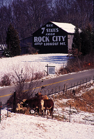
Entrepreneur Garnet Carter launched his tourist attraction on the escarpments of Lookout Mountain overlooking Chattanooga, Tennessee in 1932, but few tourists were attracted until around 1937, when he conceived the idea of painting a message on barns along what were then major thoroughfares leading to Chattanooga and sent out an enterprising, young sign painter named Clark Byers to make it happen.

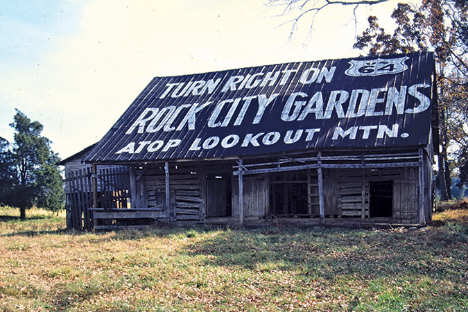
By 1937, the Great Smoky Mountains National Park had been established, and the sleepy little villages of Gatlinburg in Tennessee and Maggie Valley in North Carolina were beginning to attract numbers of visitors from the Midwest and Northeast. It made perfect marketing sense to entice them to continue on to “See Rock City atop Lookout Mountain.”

In 1994, Bill Chapin, nephew of Garnet Carter and president of Rock City Gardens, commissioned me to find and photograph all the remaining Rock City Barns. 

With 35-year-old, often sketchy records and occasional hearsay reports as my only sources of information, finding the sites was an endlessly fascinating piece of detective work, leading me 35,000 miles to more than 500 sites in 15 states. 

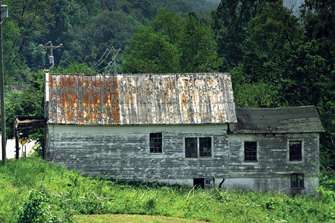
Barns have burned, blown down, been bulldozed for highway construction or simply fallen from disuse and disrepair. To complicate things still further, highways have been changed, re-routed and re-named. Often, the only way to locate a site was to find someone who remembered the property owner:

“Do you remember so-and-so, who had a place out on Highway 19 south of here?”

“Oh, sure, knowed him well. He and my daddy used to go fishin’ together all the time. Good ol’ feller. He’s dead now.”

“Well, he had this barn on his farm, with a sign that said ‘See Rock City.’ Here’s an old picture of it.”

“Sure, I remember that ol’ barn. Fact is, I helped him take it down, back around 1985. It had got all rotten and falling down, y’know. Weren’t safe.”

This barn, 3.5 miles from the 129/411 junction in Tennessee, has recently been repainted by Rock City and appears to be in good shape.

I also learned to take information with a grain of salt. The people most familiar with an area are often the least observant. In Robbinsville, North Carolina I asked a gas station attendant about a barn. “Oh, sure,” he said, “it was just down the road here, ‘bout a half mile. But it’s been torn down.” Checking for myself, I found that not only was the barn still standing, it had just been repainted and was one of the rare barns with “See Rock City” signs on two sides!

What began as a job became a labor of love as I grew to treasure the dignity and individuality of each old structure. I learned to see beauty even in the isolation in which so many barns are ending their days. As a veteran photographer, I know most of the ways to help subjects look their best, but I soon learned that the barns wanted to be photographed simply and directly, without artifice. They seemed to say, “Here we are. This is the way we are. Please let us speak for ourselves.”

So here they are. I hope they will speak to you:

This nearly gone structure is located on old U.S. Highway 19 about a mile inside the Bryson City, North Carolina, city limits and across from the Bear Hunter Campground.
On U.S. 411 near Madisonville, Tennessee, this is a log barn, but since publication of the Rock City Barns book, the owners have covered it with boards and painted it red. Sign is faded, but readable.
Along U.S. 411/441 at Garner Hollow Lane, about 11 miles west of Sevierville, Tennessee. This barn is apparently still being painted by Rock City and actually looks a bit better than when photographed for the 1996 book.
U.S. highways 64/74 -- 13 miles west of Murphy, North Carolina,  at Sunny Point Road.
U.S. highways 64/74 — 13 miles west of Murphy, North Carolina, at Sunny Point Road.
Not much change in this one, along U.S. highways 19/129 at Topton, North Carolina, just west of the 19/129 junction.
On U.S. Highways 411/441 about three miles south of Sevierville, Tennessee. Very well preserved and still looks as it did in the book.


Want more? Check out this great Pinterest Board for extra images of Rock City Barns!


You Might Also Like:

A Virginia Historical Marker stands at the entrance to Green Pastures.

Green Pastures’ picnic area was build by the Civilian Conservation Corps in the late 1930s.

Green Pastures Reborn

When it officially opened in 1940 — in the depths of the Jim Crow era — Green Pastures was likely the first U.S. Forest Service recreation area in the nation constructed for African Americans.
Chimney Tops Trail in Great Smoky Mountains National Park rewards a steep climb with exceptional mountain views.

Inset: Gatlinburg, Tennessee’s Chimneys Picnic Area sits beside the West Prong of the Little Pigeon RIver.

11 Picnics with a View

These bucket-list destinations are perfect spots to kick back, enjoy a delightful meal and take in the great outdoors.
At Hayfields State Park in Highland County, Virginia, easy-to-moderate trails wind through quiet forests and past historic structures.

Greening the Blue Ridge Region

New Parks, Healthier Creeks, Solar Power, Protected Lands and More.
Vernon and Toni Wright turn grains grown on their family farm into freshly distilled spirits.

Virginia Century Farm Home to New Distillery

For nearly 200 years, Vernon and Toni Wright’s family has raised corn, cattle and quarter horses at Hill High.
Spring wildflowers bloom early in the New River Gorge of West Virginia. From the photographer: “Bloodroot is one of the first to blossom, fittingly coming in around the first day of spring. The reddish sap that exudes from all parts of the plant — especially the root — when cut is what gives bloodroot its common name.”

Scenes of Spring: A Photo Essay

Our contributing photographers reveal the fresh sights and subtle joys of the season.
John Scrivani bags female flowers from atop a 40-plus-foot-tall chestnut.

The Good Steward

Veteran forester John Scrivani dedicated his career to restoring American chestnut trees — and helped lay the groundwork for the effort’s next generation.
The pond next to the visitor center entrance is easily accessible and a beautiful spot for a selfie or an afternoon of plein air painting.

How to Make a State Park

The opening of Virginia’s newest state park marked the culmination of a community dream carefully nurtured for more than a decade.
Several bridges help hikers make their way over the stream.

Kentucky’s Bad Branch Falls: A (Fairly) Tame Trek Through the Forest

You’ll know the impressive 60-foot cascade is near when the path turns rugged.
Daybreak at Elakala Falls in West Virginia’s Blackwater Falls State Park on a perfect winter morning.

Quiet Beauty of Mountain Winter: A Photo Essay

Our contributing photographers braved the chill to capture the calm of the cold months.
The original Academy burned in 1911.

Curios: When Lynchburg, Virginia, Was King

With the likes of Douglas Fairbanks, Duke Ellington and Louis Armstrong performing live, the little city with the highest per capita income in the U.S. was a national hotspot for entertainment.

CALENDAR OF EVENTS