Photo Essay: Appalachian Trail Beauty Spots

Newfound Gap to Charlies Bunion: Follow U.S. 441 south from Gatlinburg, Tennessee, to the Newfound Gap parking area in Great Smoky Mountains National Park. Take the A.T. 4.1 miles to Charlies Bunion. The first 2.5 miles is rather difficult with a large elevation gain, rocks and roots. The remaining 1.6 miles along the ridge line offers beautiful views of the forest and of the Smokies. Once you reach Charlies Bunion, be cautious of the drop-offs on each side as you take in one of the most iconic views of the A.T.

Photographer Joshua Moore, who lives in Church Hill, Tennesee, knows his area’s part of the Appalachian Trail just about as well as he knows his cameras.  His work has been published by National Geographic YourShot, Shutterbug Magazine, B & H Photography and many others. He is also a volunteer photographer for the National Park Service, and conducts photography classes. Learn more at joshtmoore.com

Once we looked at a few of his shots of the trail, we asked him if he’d match up our favorites with directions to walk to where he found the shots.

Enjoy the photos, consider the treks. 

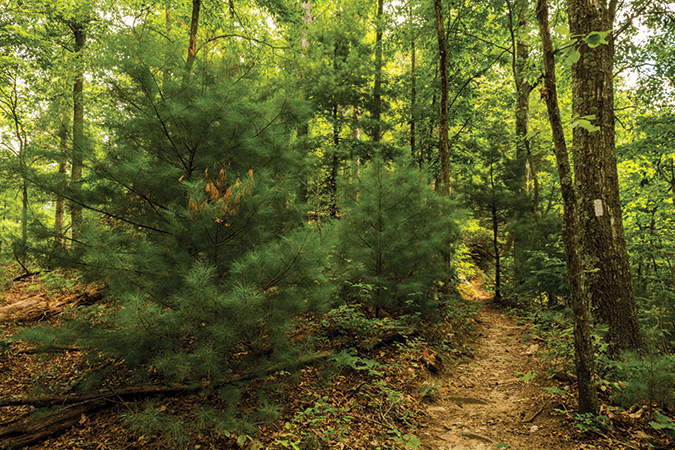
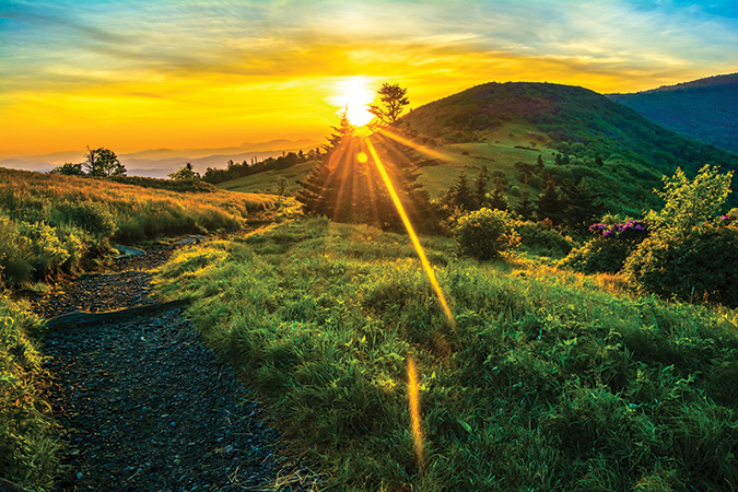
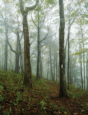
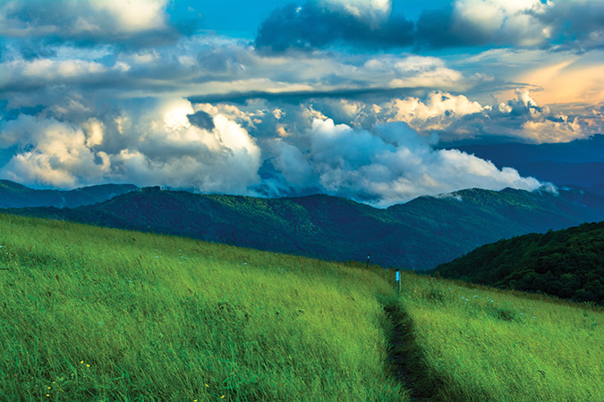
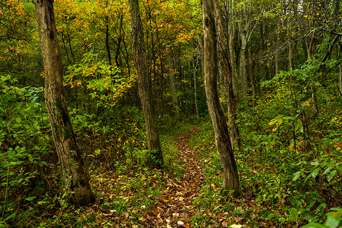
Photo Above: Newfound Gap to Charlies Bunion: Follow U.S. 441 south from Gatlinburg, Tennessee, to the Newfound Gap parking area in Great Smoky Mountains National Park. Take the A.T. 4.1 miles to Charlies Bunion. The first 2.5 miles is rather difficult with a large elevation gain, rocks and roots. The remaining 1.6 miles along the ridge line offers beautiful views of the forest and of the Smokies. Once you reach Charlies Bunion, be cautious of the drop-offs on each side as you take in one of the most iconic views of the A.T.

Watauga Lake: Park along Wilbur Dam Rd., in eastern Tennessee, heading towards the TVA Watauga Dam Visitors Center at a small pull-off. Look for the wooden sign that reads “Big Laurel Branch Wilderness, Cherokee National Forest.” Follow the Appalachian Trail up the mountain for 5.1 miles to the Vandeventer Shelter, for stunning forest views and views out over Watauga Lake.
Roan Highlands: Carvers Gap to Jane Bald (both photos). From Roan Mountain, Tennessee, follow U.S. 143 to the state line (Carvers Gap), and the parking area. Cross the road and follow the A.T. for 1.2 miles to Jane Bald. This section starts in pine forest, but yields to 360-degree views of the beautiful Roan Highlands.
Beauty Spot: From Erwin, follow TN 395 (Rock Creek Rd.) to Beauty Spot Gap Rd, to the Beauty Spot Parking area. Beauty Spot is 30 yards from where you park and you can follow the A.T. from there into the Roan Highlands. Beauty Spot, along the North Carolina/Tennesse line, is a bald that offers up stunning views of the Roan Highlands.
Max Patch: Take Exit 7 from I-40 E, then take Cold Springs Creek Rd., which turns into Harmon Den Rd. to North Carolina State Rte 1182, where the Max Patch parking area will be on the right. Follow the trail for .8 mile to the top of Max Patch and a connection to the Appalachian Trail. Max Patch offers of 360-degree views over a span of 350 acres in the Pisgah National Forest.
Shady Valley: Follow US 91 to the intersection of Osborne Ln. and Cross Mountain Rd. to the Cross Mountain parking area. You will then have a choice: follow the A.T. into the forest for a beautiful woodland hike; or cross the road and follow the A.T. for a 1.5-mile hike through a field with views of Shady Valley, Tennessee, and the Blue Ridge Mountains.


The story above appears in our March/April, 2020 issue. For more subscribe today or log in to the digital edition with your active digital subscription. Thank you for your support!


You Might Also Like:

Elizabethton, Tennessee, USA, - May 15, 2021: Reenactment at Sycamore Shoals State Historic Park of the Siege of Fort Watauga in 1776.

Revolutionary Roundup

On July 4, 1776, a new nation was born. In honor of this historic day, we explore the forts, battlefields, museums, trails, and more that trace the Patriots’ journey to freedom in the Blue Ridge Mountains.
2025 Festivals and Events

2026 Festivals & Events Guide

From the Virginias and the Carolinas to Georgia, Tennessee, and Kentucky, our annual compendium is the perfect travel companion.
A happy 8-year-old Eula Mae standing in front of her father, Woodrow, in this Golding family photo taken in 1952.

My Beloved Scenic

Before it became America’s Favorite Drive, the Blue Ridge Parkway was a farm family’s front yard, playground, and memory lane.
A bee clings to the center of a sunflower at Mill Springs Farm, located just up the road from historic downtown Jonesborough, Tennessee. From the photographer: “The farm grows a yearly crop of a variety of sunflowers. The bees love them!” Photo by Jay Huron

Among The Blooms: A Photo Essay

Our contributing photographers wandered the mountains in late spring and early summer to capture critters big and small frolicking, nibbling, and buzzing about.
2027 Best of the Mountains Awards

2026 Best of the Mountains Awards

Submit your nominations for the finest in the Blue Ridge today!
Hikers willing to take on a moderate climb are rewarded with incredible panoramas from the summit of Marys Rock.

An Insider’s Guide to Shenandoah National Park

This year is a landmark one for this treasured piece of mountain land in Virginia: the 100th anniversary of Congress authorizing its establishment and the 90th anniversary of its dedication.
Blue Ridge Country Parkway Guide 2026

2026 Blue Ridge Parkway Guide

Start planning your next trip on America's Favorite Scenic Highway
A Virginia Historical Marker stands at the entrance to Green Pastures.

Green Pastures’ picnic area was build by the Civilian Conservation Corps in the late 1930s.

Green Pastures Reborn

When it officially opened in 1940 — in the depths of the Jim Crow era — Green Pastures was likely the first U.S. Forest Service recreation area in the nation constructed for African Americans.
Chimney Tops Trail in Great Smoky Mountains National Park rewards a steep climb with exceptional mountain views.

Inset: Gatlinburg, Tennessee’s Chimneys Picnic Area sits beside the West Prong of the Little Pigeon RIver.

11 Picnics with a View

These bucket-list destinations are perfect spots to kick back, enjoy a delightful meal and take in the great outdoors.

CALENDAR OF EVENTS